New 2011 Census Data Counts

We are delighted to announce that we have now released our own census counts which are available in Excel Spread sheet format and at various levels of geography including Postcode Sector/ District and Output Area level for the entire United Kingdom.
We have also made Postcode Sector level census counts available for selected Postcode Areas to help small local businesses plan more effectively without the cost of the national data files.
What Is The Census?
A national census of households is conducted every ten years to provide a complete picture of the nation. It allows us to compare people across different areas of the United Kingdom because the same questions are asked in the same way throughout England, Wales, Scotland and Northern Ireland.
This census information provides information that government needs to develop policies, plan and run public services, and allocate funding.
Why Use Census Counts?

Raw census information at an individual household level is not publicly available in order to protect individuals' privacy and anonymity under data protection laws. However, the information can be used to release counts of types of people and households at various levels of geographic area helping to paint a picture of people in areas across the country.
Typical uses for census counts are:
- Locating your ideal customers/ audience.
- Calculating the size of your potential market and, as a result, your sales potential.
- Targeting advertising and marketing activity to appropriate audiences.
- Estimating leaflet volumes for Door to Door campaigns.
- Assessing retail catchment area potential
- Balancing sales territories by sales potential and establishing appropriate sales targets.
- Sizing balanced and equitable franchise areas
What Information Does the Census Provide?
We have collated the most popular census counts for business use resulting in 183 individual census variables across 16 themes including:- Age Structure
- Car or van availability
- Communal establishment residents
- Dwellings, household spaces and accommodation type
- Economic activity
- Ethnic group
- Health and provision of unpaid care
- Household composition
- Industry
- Lone parent households with dependent children
- Marital and civil partnership status
- NS-SeC
- Occupation
- Qualifications and students
- Tenure
- Usual resident population
Download a full field list here >
How Do I Use It?
You can load the Excel spreadsheet of census counts into your own spread sheet, database package or even Geographic Information System (GIS) for analysis and mapping.
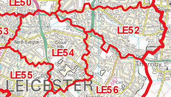
Or alternatively you can use the spread sheet in Excel alongside a simple wall map to understand local areas better. For example, the following image shows the area covered by two Postcode Sectors on the outskirts of Leicester: LE5 4 and LE5 2.

Census counts helps us understand what kind of people live in these areas. For example, if we look up these two Sectors in our census data we find the following:

Immediately we can see that LE5 4 has a slightly higher population and number of households; but with 183 census fields provided for every Postcode Sector we can make quite detailed comparisons between areas. For example:
- There are twice as many people in LE5 4 working in Manufacturing than in LE5 2 but twice as many people in LE5 2 work in Construction.
- There are 65% more detached houses in LE5 2 than LE5 4 but 8 x as many flats in LE5 4.
- LE5 2 has a higher proportion of retired residents and fewer children/ young families than LE5 4.
- And so on.
So if you know the kinds of people or households you need to promote your products to or offer services to, census data can help find those areas where you will be most successful or most needed.
We will look at ways of manipulating Census counts to make comparisons easier in future bog posts.
What Geographic Areas Are Counts Available For?
Our census counts are available for the entire United Kingdom (England, Scotland, Wales and Northern Ireland) at various geographic levels including:- Over 230,000 Output Areas averaging 119 households per Output Area (Download Sample)
- Over 9,000 Postcode Sectors averaging 2,990 households per Postcode Sector (Download Sample)
- Over 2,700 Postcode Districts averaging 9,910 households per Postcode District (Download Sample)
- Other geographies available upon request.
The counts are also available at Postcode Sector level for individual UK Postcode Areas >
To find out more or if you have any questions about census counts then please let us know >

